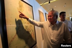
Discovery of a nearly 70-year-old map of the South China Sea could help Beijing support its claim in Asia’s biggest maritime sovereignty dispute, but it would face criticism abroad and fall outside the scope of international law, experts say.
The 1951 map, as described in an article by five Chinese researchers, includes coordinates in the 3.5 million-square-kilometer sea that offer Beijing a clearer-than-ever show of where its waters and islets lie, maritime scholars say. Today China uses a U-shaped nine-dash line that leaves spaces between those lines open to interpretation.
Chinese officials have not so far used the map to change policy. They might be waiting to see what decision-makers elsewhere think, said Euan Graham, international security director with the Lowy Institute for International Policy.
Brunei, Malaysia, the Philippines, Taiwan and Vietnam also claim all or parts of the sea that’s prized for fisheries, oil and gas. China has irritated them all over the past decade by landfilling disputed islets for military use.
International courts would probably reject the map as a legal tool, Graham said.
“Maps don’t carry independent legal weight. You can submit as many maps as you like, but the map changes nothing as regards the legality of claim,” he said. “It’s part of a broader campaign that China has long pursued, which is to build an evidential base amongst scholars that this is not a confected recent claim.”
A more vivid demarcation line
The map, as described by the scholars in an undated 2018 Science China Press article, fills in gaps between nine thick lines that China uses now to describe the boundary around its disputed claims extending from Hong Kong to Borneo. Foreign scholars became aware of the article this month.
“It is an important historical map that clearly proves the U-boundary line is the border of China’s territorial sea in the South China Sea,” the article says. It may also be China’s first map produced under Communist Party rule.
China cites records extending back into dynastic times as support for its claim to more than 90 percent of the sea. If it adopted the map as a policymaking tool, that would mean China wants to end the “ambiguity” of its nine-dash line, Graham said.
“I think this just shows their determination to keep the South China Sea as a part of China,” said Alex Chiang, international relations professor at National Chengchi University in Taipei.
The nine-dash line caused has confusion over the past year as Vietnam, the most vocal among the other claimants, explored the sea for oil and gas.
Awaiting reactions
Officials in Beijing may be waiting for reactions from other countries before they decide how to use the map, said Gregory Poling, director of the Asia Maritime Transparency Initiative of the American think tank Center for Strategic and International Studies.
“It could be nothing more than a scholarly curiosity, or it could be an attempt to put this idea out there as a trial balloon and see how the international community responds,” Poling said.
Suspicious reactions could make the matter disappear rather than become government policy, Graham said. But the Southeast Asian claimants, all militarily weaker than China, are unlikely to sound off, he said.
China has offered those countries investment and economic aid to steady relations since 2016, when a world arbitration court rejected the legal basis for Chinese claims at the time.
But Taiwan, Vietnam and the Philippines might eventually protest, Chiang said. China for its part wants to avoid conflict, he said, and look first for diplomatic solutions to sovereignty disputes.
Questioned as a legal document
Public opinion may decide the map’s role in Chinese policymaking, as it can’t stand up to the United Nations Convention on the Law of the Sea, scholars say.
China would need to show “occupation and continuous administration” of waters inside the U-shaped line, said Carl Thayer, Southeast Asia-specialized emeritus professor at the University of New South Wales in Australia. Islets in the U-shaped line were largely uninhabitable in 1951.
The 1951 map was neither “appended to a treaty” nor issued by the Chinese government, he added, further weakening its clout under international law.
China’s Communist government, in power for just two years then, had little international support “rather than universal recognition,” said Alan Chong, associate professor at the S. Rajaratnam School of International Studies in Singapore. Chinese scholars may lack understanding of international law as well, he said.
“Will this stand up in an international court of law? I have my doubts,” Chong said. “If this surfaced in an international court, the decision could go either way. It is not what you call incontrovertible proof, because in 1951 the People’s Republic of China was not officially recognized by a lot of states.”